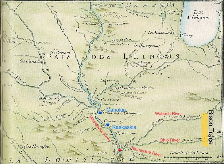
In 1702, Charles Juchereau de Saint-Denis, a Québec City born entrepreneur, erected a first fort, at the red dotted point identified as “ancien fort” (old fort) on the map near the mouth of the Ohio River.
The fortification served to protect a profitable tannery, nicknamed Va Bache, that Saint-Denis built somewhere east of the Mississippi toward the actual city of Metropolis for the tanning of bison hides. The animal skins came from his trading business with indigenous people that was granted to him by King Louis XIV of France. The success of the enterprise gave the authorities of French America a keen awareness of the strategic importance of the Ohio River for connecting Canada with Colonial French Louisiana. In that regard, the site of Fort Duquesne at the beginning of the “Beautiful River” had everything to do to with wanting to control the Ohio River from start to end (see Pittsburgh).
The site of Fort Va Bache, at the end of the “Beautiful River”, did allow quick eastward access to three waterways leading to the Bison Trace, a great migratory trail(see diagram), that is to say (1) the Ouabache River also called the Saint-Jerome, (2) the river of the departed Shawnee(or Erie) Nation, also called the Cat or Puma people, and (3) the Casquinambaux River (or the river of the Cherokees) who were a powerful nation in the Southeast.
Fort Ascension became Fort Massiac then Massac

On Ascension Day May 19, 1757, the Marine troops started to build a larger fort on the heights of the Ohio riverbank in the heart of what is Metropolis today. The place was named Fort Ascension. Under the direction of Captain Charles Philippe Aubry, Sieur de la Gautraye, who served as governor of Colonial Louisiana twice in the 18th century, the fort was completed in 30 days. It had eight cannons and was garrisoned by about 150 men. Its main role was to supply Fort Duquesne, built in 1754 (at Pittsburgh where the Ohio River is formed by the confluence of the Allegheny and Monongahela rivers at Point State Park in downtown), Fort Presque Isle (1753, at Erie), Fort LeBoeuf (1753, at Waterford) and Fort Machault (1754, at Franklin). These four forts, all located in present day Pennsylvania State, constituted New France’s defence line, south of Lake Erie.
In 1759, Fort Ascension was renamed Fort Massiac in honor of Claude Louis d’Espinchal, Marquis de Massiac, Minister of the Navy and Colonial Affairs in the reign of King Louis XV of France. Following the Treaty of Paris of 1763, the wooden fort was transferred to the British and took the anglicized name of Fort Massac. However, very shortly thereafter it was set on fire by members of the Chickasaw Nation. In 1794 the fort was rebuilt by the Americans and dismantled at the end of the War of 1812. A replica of Fort Massac was erected in early 1970 alongside the ruins of Fort Massiac, the French fort.